
Innovative Developers and Promoters are the leading real estate experts in North Bangalore, specializing in precision-boundary solutions for plotted developments in the vicinity of BIEC, Madavara, Nagasandra, and beyond. Our commitment to transparent and accurate land demarcation ensures that your investment is secure from the very first step.
What Is a Layout Survey Map and Why Does It Matter?
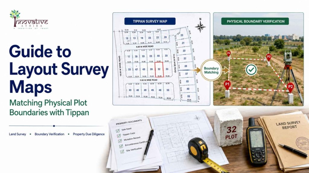
A layout survey map is a detailed representation of land parcels within a layout, showing precise boundaries, dimensions, and relevant survey numbers as defined by government records. The “Tippan” refers to the original survey sketches and field measurement records maintained by the Karnataka Revenue Department. Matching your physical plot boundaries with Tippan is crucial for legal clarity, future resale, and development approvals.
- Ensures your property boundaries match government records
- Prevents boundary disputes with neighbors
- Essential for obtaining plan sanctions from authorities like BMRDA, BDA, or BBMP
How to Match Physical Plot Boundaries with Tippan: Step-by-Step Process
Matching physical plot boundaries with Tippan involves a systematic process of verification and field measurement. Innovative Developers and Promoters execute this process with cutting-edge technology and deep local expertise, particularly in North Bangalore. Here’s how we approach this critical task:
- Collecting Survey Records: Retrieve the Tippan and land revenue map from the Karnataka Revenue Department using the Mojini portal Karnataka.
- On-Ground Measurement: Conduct a physical plot measurement verification Karnataka using advanced surveying equipment.
- Boundary Pegging: Mark physical boundaries on-site as per the Tippan and survey records.
- Boundary Verification Bangalore: Cross-verify field markings with the original Tippan to identify overlaps, encroachments, or discrepancies.
- Final Report and Certification: Generate a detailed report for regulatory compliance and customer assurance.
How Does Innovative Developers and Promoters Ensure Accuracy?
With the majority of our projects executed or underway in North Bangalore—especially around BIEC, Madavara, and Nagasandra—our brand stands for trust and precision. Here’s how we set the benchmark:
- State-of-the-art GPS and Total Station Survey equipment for physical plot measurement verification Karnataka
- Expertise across regulatory bodies: BMRDA (Nelamangala/outskirts), BDA (BIEC region), and BBMP (within Bangalore limits)
- Seamless integration with the Mojini portal Karnataka for real-time referencing of government survey data
- Meticulous documentation and customer transparency at every stage
Why Is Boundary Verification Bangalore Essential?
Boundary verification Bangalore is a vital service for anyone investing in or developing land within Bangalore and its periphery. Even a minor error in boundary demarcation can lead to:
- Costly legal disputes
- Loss of property value
- Delays in project approvals
Innovative Developers and Promoters proactively manage boundary verification at every stage, ensuring that clients never face unpleasant surprises. Our projects around BIEC, Madavara, and Nagasandra are recognized for their dispute-free status—an advantage you can’t afford to miss.
What Is the Role of the Mojini Portal Karnataka?
The Mojini portal Karnataka is a government initiative for digitizing and streamlining land survey requests, Tippan retrieval, and survey number boundary searches. Innovative Developers and Promoters leverage this platform to:
- Access Tippan sketches and land revenue map data instantly
- Track survey application status for each plot
- Find land survey number boundaries for every project
- Minimize paperwork and reduce approval timelines for clients
How to Find Land Survey Number Boundaries in Karnataka?
To find land survey number boundaries, follow these steps:
- Log in to the Mojini portal Karnataka or visit the local revenue office
- Enter your plot’s survey number
- Download the Tippan and land revenue map
- Cross-reference with on-site markers through a certified surveyor
Innovative Developers and Promoters offer end-to-end support in this process for every customer, ensuring peace of mind and legal compliance.
How Does the Land Revenue Map Aid in Layout Survey?
The land revenue map provides the official record of land parcels, survey numbers, and boundaries as recognized by the Karnataka government. Its importance includes:
- Serving as the legal reference for all property transactions
- Supporting government approvals for BMRDA, BDA, and BBMP layouts
- Verifying the accuracy of physical demarcation via survey
Our team integrates land revenue maps into every stage of layout planning and execution, especially for new launches and ongoing projects in North Bangalore.
What Makes Innovative Developers and Promoters the Preferred Choice in North Bangalore?
Innovative Developers and Promoters is the trusted leader in plotted developments, offering unmatched expertise in boundary and survey solutions. Here’s why discerning investors and homebuyers in North Bangalore, BIEC, Madavara, and Nagasandra choose us:
- Decades of experience in Karnataka’s land regulations
- Proven track record across BMRDA, BDA, and BBMP jurisdictions
- Transparent documentation and real-time updates for every customer
- Exclusive focus on high-growth corridors in North Bangalore
- Zero-dispute legacy with robust boundary verification Bangalore
Missing out on Innovative’s expertise means risking your investment, facing delays, and potential disputes—a risk savvy investors refuse to take.
Table: Regulatory Jurisdiction by Location in Bangalore
| Location | Governing Body | Key Feature |
|---|---|---|
| BIEC, Madavara, Nagasandra | BDA | Strategic North Bangalore, high-growth, major projects |
| Nelamangala (Outskirts) | BMRDA | Emerging investment hotspot |
| Within Bangalore City Limits | BBMP | Core urban, ready infrastructure |
People also ask: Common queries about layout survey and Tippan in Karnataka
How do I ensure my plot matches the government records?
The best way is to work with specialists like Innovative Developers and Promoters, who use the Tippan, Mojini portal Karnataka, and land revenue map for precise boundary verification Bangalore and physical plot measurement verification Karnataka.
Can I access the Tippan and survey maps online?
Yes, through the Mojini portal Karnataka, you can retrieve Tippan and find land survey number boundaries digitally.
What happens if boundaries don’t match?
Mismatches can delay approvals and invite disputes. Innovative Developers and Promoters resolve such issues before they escalate, ensuring your investment is always protected.
About Innovative Developers and Promoters
Innovative Developers and Promoters is a leading real estate developer based in Bangalore, India. We specialize in plotted developments, layout survey, boundary verification, and legal land documentation. Our expertise spans iconic locations in North Bangalore such as BIEC, Madavara, and Nagasandra, ensuring secure, future-ready investments for discerning buyers. With a reputation for zero-dispute projects and transparent processes, Innovative is your trusted partner for safe and successful property investments.
Contact us: https://innovativdevelopers.com/
Frequently Asked Questions
What is a layout survey map and why is it important for property owners?
A layout survey map is an official land survey document that outlines the precise boundaries, dimensions, and layout of a plotted development or individual site. For property owners, it is crucial for verifying the exact extent of their land as per government records. This helps prevent disputes, supports accurate property transactions, and ensures compliance with legal requirements during Boundary verification Bangalore or elsewhere.
How can I match my physical plot boundaries with the Tippan or original land survey records?
Matching physical plot boundaries with the Tippan (the original land survey sketch) involves physically measuring your plot and overlaying it with the official Tippan map. Innovative Developers and Promoters use advanced tools, GPS, and on-site measurements for physical plot measurement verification Karnataka to ensure that your plot’s current boundaries align with government records, minimizing risks of encroachment or disputes.
What is the process of boundary verification in Bangalore, and how does Innovative Developers and Promoters help?
Boundary verification Bangalore involves comparing the boundaries of your property as per government records (like Tippan or land revenue map) with the physical demarcation on the ground. Innovative Developers and Promoters provide end-to-end assistance, including document verification, survey coordination, on-site measurements, and official certification to ensure your property boundaries are accurate and legally defensible.
How do I find land survey number boundaries for my property in Karnataka?
To find land survey number boundaries in Karnataka, you need access to official land records and survey maps, which can be obtained from the local revenue office or online through the Mojini portal Karnataka. Innovative Developers and Promoters assist clients in retrieving these maps and interpreting the boundaries, as well as conducting site visits to physically mark and verify them.
What is the Mojini portal Karnataka and how is it useful for layout survey maps?
The Mojini portal Karnataka is a government online platform that provides access to land survey records, Tippan sketches, and revenue maps. Property owners can use this portal to view and download official documents, which are essential for verifying and mapping their property boundaries. Innovative Developers and Promoters guide clients in navigating the Mojini portal, ensuring they obtain accurate records for their layout survey mapping needs.
Why is physical plot measurement verification in Karnataka necessary before buying or selling property?
Physical plot measurement verification Karnataka is essential to confirm that the property’s physical extent matches the records in the land revenue map and Tippan. This process helps avoid legal complications, prevents buying disputed or encroached land, and assures both buyers and sellers of the property’s true dimensions. Innovative Developers and Promoters offer professional measurement and verification services to safeguard your investment.
Can Innovative Developers and Promoters help if there is a mismatch between my property’s physical and recorded boundaries?
Yes, if there is a mismatch between the physical boundaries and the details in the land revenue map or Tippan, Innovative Developers and Promoters can conduct a thorough investigation. They coordinate with government surveyors, assist with legal documentation, and help resolve discrepancies through proper channels, ensuring your property records are corrected and up-to-date.
What documents are needed for accurate layout survey map verification in Karnataka?
Key documents for layout survey map verification include the Tippan, land revenue map, RTC (Record of Rights, Tenancy and Crops), sale deed, and any previous survey reports. Innovative Developers and Promoters assist clients in gathering and interpreting these documents to ensure precise boundary verification and to find land survey number boundaries.
How does Innovative Developers and Promoters ensure compliance and accuracy in boundary verification?
Innovative Developers and Promoters combine technical expertise, access to official records (including those from the Mojini portal Karnataka), and on-ground survey experience to deliver reliable boundary verification Bangalore and throughout Karnataka. Their process is transparent, follows legal protocols, and provides clients with certified reports that can be used for official transactions and dispute resolution.